4. Datum Realizations
Chapter D. The North American Datum of Topic XII discussed the NAD evolution. Control positions have been readjusted multiple times since NAD 83 was adopted. While the original NAD 83 (1986) realization included all existing control measurements, subsequent readjustments shifted toward only including control points with contemporary measurements. This was done to maintain reference network accuracy: combining early 20th century transit & tape measurements with current GPS observations would be detrimental to network integrity. Additionally, many older points were either lost or are inaccessible or in non-favorable locations so their positions were not subsequently updated.
Points which were historically part of the national control network were still included in subsequent NAD 83 updates until NAD 83 (2007). Breginning with that realization only GNSS horizontal points were included. Because GNSS was so much more accurate than traditional ground-based measurenents (some dating all the way back to before 1927) the older mesaurenments were not included because they would degrade the network,
Pre-NAD 83 (2007) control points are called passive points and are their accuracy is still given in tems of FGCC Order and Class.
The most current realization is NAD 83 (2011). In addition to being GNSS based, these control points also have accuracies expressed as Network and Local as per the FGCS specifications.
The CURRENT SURVEY CONTROL datasheet section identifies the last realization in which the point was adjusted. Figure I-16 shows the current position information for two control points: Merrill GPS Az Mk and Voigt.
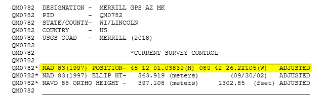 |
| (a) Point Merrill GPS Az Mk |
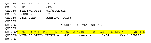 |
| (b) Point Voigt |
| Figure I-16 Current Control Data |
Although they are within a few miles of each other, their current positions are not on the same datum realization.
Surveyors who use NSRS control points either for traditional total station traversing or as base receiver locations for a GNSS survey must pay attention to the datum realization information on a datasheet. Mixing control based on different realizations can cause problems.
The SUPERSEDED SURVEY CONTROL datasheet section shows a point's position in previous realizations. If Voigt and Merrill GPS Az Mk will be used together, the latter's NAD 83 (1991) position must be used, Figure I-17.
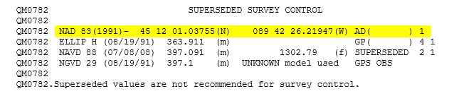 |
| Figure I-17 Point Merrill GPS Az Mk's Previous Positions |
Although position differences between realizations may be small, they can be significant. At Merriill GPS Az Mk, NAD 83 (1991) to NAD 83 (1997) latitude and longitude shifts are +0.00084" and +0.00158", respectively. That may not seem like much, but they are approximately 0.08 ft east and 0.16 ft north, which will affect survey closure.
When using multiple control points for a project, it is critical they be on the same datum realization and, unless necessary for historical purposes, on the most recent one.